Where to ride
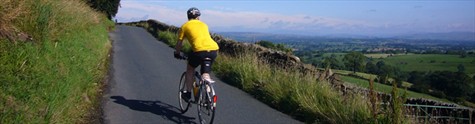
The East Riding of Yorkshire is full of beautiful scenery, bustling market towns and secluded rural villages with a variety of terrains which make it perfect for cycling. The area has an extensive network of on and off road cycle paths suitable for all ages and abilities, and all our towns and larger villages have centrally located secure cycle parking facilities.
A number of national cycle networks and routes pass through the East Riding and there are lots of different cycle maps available to help you plan a ride in the area.
There are some great cycle routes around the East Riding of Yorkshire and the Council has produced several leisure cycle route maps with rides running from locations across the East Riding.
Popular Cycle Routes
Visit Hull and East Yorkshire have developed eight ‘Big Skies bike rides’ which run through the beautiful scenery of the Yorkshire Wolds and the surrounding towns and villages. Free maps of the rides can be downloaded here.
The Trans-Pennine Trail in the east stretches from Barnsley to the great port of Kingston upon Hull and through the East Riding on a traffic-free rail path to the seaside town of Hornsea.
East Riding / Hull – Hornsea railpath (TPT & NCN 65)
National Cycle Network Routes 1, 55, 65, 66, 164, 166 all pass through East Riding.
The Way of the Roses cycle route is a 170 mile ride from Morcambe in the west to Bridlington in the east. The route runs through the East Riding from Stamford Bridge, through Pocklington and Driffield before finishing on the seafront at Bridlington.
The North Ferriby to Hessle route (NCN 65) has a short section that takes you along the foreshore and under the impressive Humber Bridge (approximately two miles). This can be linked in with a trip around the Humber Bridge Country Park.
The Yorkshire Wolds Cycle Route is a 146 mile circular route in and around the Yorkshire Wolds, passing through numerous towns and villages including Beverley, Pocklington, Bridlington and Driffield.